Roads: compromise is needed now on highways solutions to support housing growth and address current issues for residents
October 28, 2025 | by Paul Ward
This update is my own personal view based on a recent presentation I gave to county councillors, the Highways department, landowners and other local representatives at a meeting on transport policy and development here.
Landowners, county Highways and planners need to collaborate on solutions now for the long-term success of Knebworth as a community
We have to think long term about overall solutions beyond just the current three existing Local Plan sites (KB1,2 and 4) as road infrastructure lasts for centuries and fundamentally shapes our community. Just bolting on cul-de-sac developments will only make our existing transport problems worse, with no strategic solution for the lack of A1(M) capacity in sight.
We have a big opportunity in front of us now to make sensible, pragmatic choices for Knebworth using investment available from new housing that can make a positive long-term difference to our community and address historic issues.
This means both promoting walking and cycling within the village as much as possible, making it a safer and nicer environment for that, but also recognising people in Knebworth need to get in and out using their cars for many journeys as it simply doesn’t have the infrastructure of a large urban town. Also some groups are not as mobile and should not be forgotten about.
There is an alternative to the current proposals on the table.
- This involves using the proposed developments now and in the future to implement some fit-for-purpose local roads through or around the new sites. These need to be designed to allow local traffic through slowly, but not encourage more B197 through traffic. This is in addition to walking and cycling improvements in the existing village and new sites. I believe this is not easy but possible if all parties collaborate.
- For the current Local Plan sites (KB1,2 and 4), at a minimum they should be facilitating this future, and certainly not blocking options off for the future. This means designing site layout and access now with an eye to the future that the next Local Plan sites may be able to implement fully.
- These additional proposals will be emerging shortly from landowners and the District Council in a “call for sites” process happening now. It’s very likely more development is proposed making a an even more pressing case for a reasonable about of new road infrastructure to cope with layers of development all around the village.
- We also need to slow traffic down in Knebworth residential roads with 20mph zones, alongside solving the village centre congestion and making safer and more attractive routes for walking and cycling. I support efforts of the Highways team to do this, with Parish Council support.
It will need collaboration and compromise from all parties involved now. This specifically means the two main land owners, their developers, the Highways and Planning officers need to collaborate and develop viable proposals to include in Masterplans and Planning Applications.
In 30 years’ time I want our children to look back and say we took action now together to make Knebworth a great place to live that has a coped well with sustained economic and housing growth. Right now I’m not convinced the current piecemeal transport plans will deliver the needed infrastructure to enable this.
Recap: Knebworth, we have a problem
The main village of Knebworth exists because of the train station. It subsequently had the A1(M) built next to it. This is both convenient for residents but also poses key constraints.
It’s grown relatively organically over the last 150 years without any overall “masterplan” actually being implemented. It’s already the biggest village in North Hertfordshire with over 4,500 people, with growth driven by its suitability for commuting, access to countryside and major towns.
Critical to our identity is Knebworth House and the Garden Village heritage of the original partly-built proposals from Edwin Lutyens a century ago. Hence it’s got two conservation areas in the main village which will be impacted by the current developments, as well as another one in Old Knebworth a couple of kilometres west of the main village.

There’s a lot more in our Neighbourhood Plan, which I’m proud to have helped develop as part of the Parish Council over the last decade.
The road infrastructure today is essentially based on the original Great North Road now B197, plus access via four old country lanes running east/west. These are linked by some other original back lanes such as Deards End Lane, Gypsy Lane and Old Lane. These have never been improved to address safety for walkers and cyclists, or capacity issues, as the village has grown.
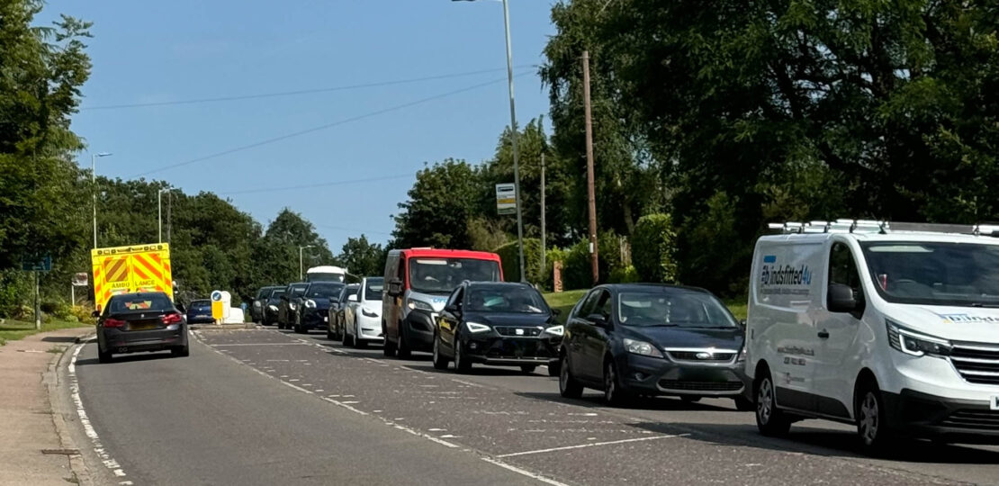
Of course, the pinch point is the village centre. This is well documented and today can be a bottleneck at essentially any time, not just with A1(M) issues. The close proximity of vehicles manoeuvring and frustrated drivers does not make it an attractive place to be for pedestrians, cyclists or drivers.
There has been some progress on this tactically with street layout options proposed by the Highways team, consulting with the Parish Council. I encourage this work and hope to see solutions implemented, potentially funded by developer contributions from the current Local Plan sites.
Looking forwards, Knebworth village is set to grow by nearly one third from the current three Local Plan sites and windfall. On top of that you have other adjacent development where people use Knebworth – hundreds of homes in Woolmer Green and Bragbury End. Plus I expect there are more sites coming forwards in the next Local Plan shortly.
All of these developments will place additional burden on the road infrastructure, even assuming we achieve a level of modal shift to more walking and cycling locally. This is just common sense and inevitable, and it is all going to be layered on top of an existing network of country lanes that are not fit for purpose.
I also think we have to assume that the A1(M) will remain a bottleneck with inadequate capacity. Nobody here today is solving that and big strategic investments from government would likely take decades.
Development in the current North Herts Local Plan 2011-31
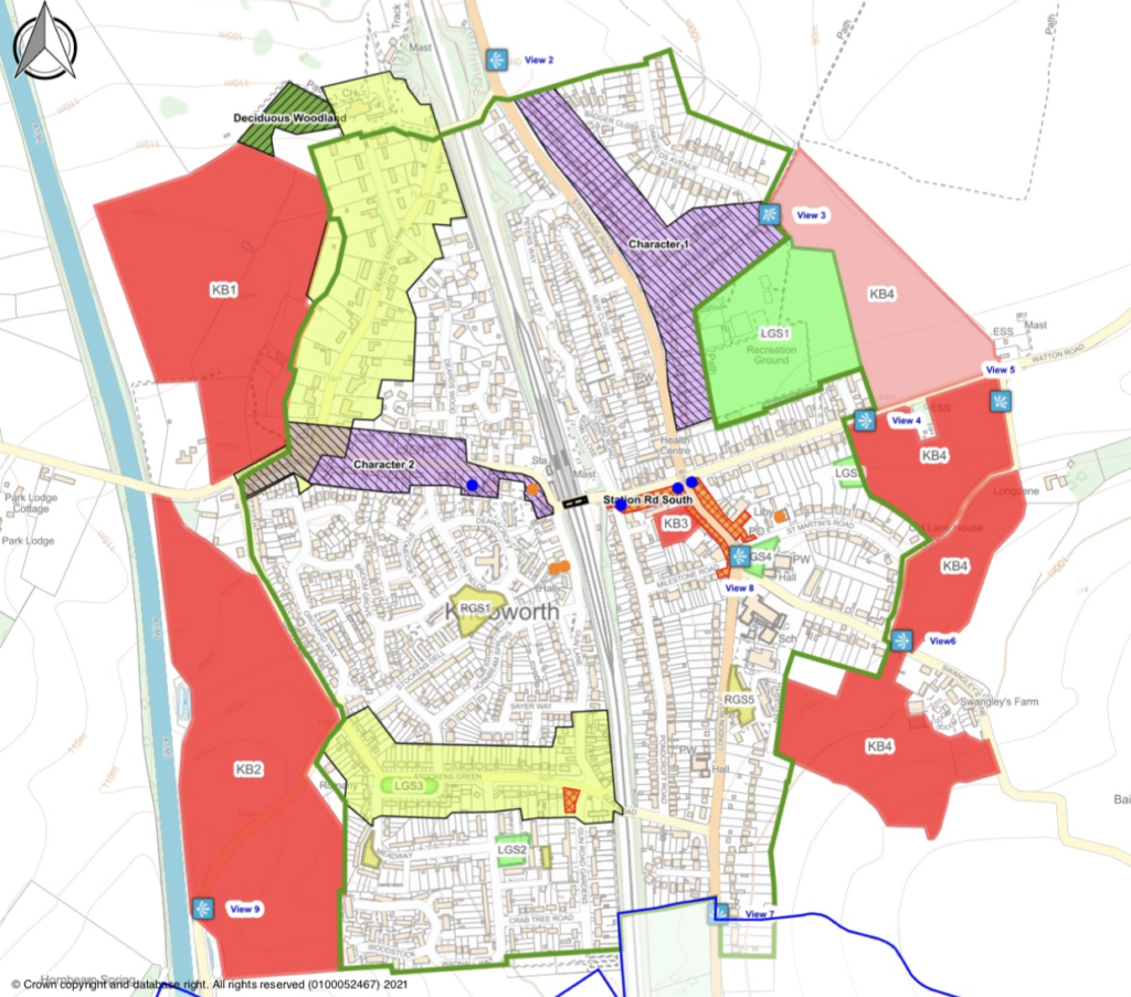
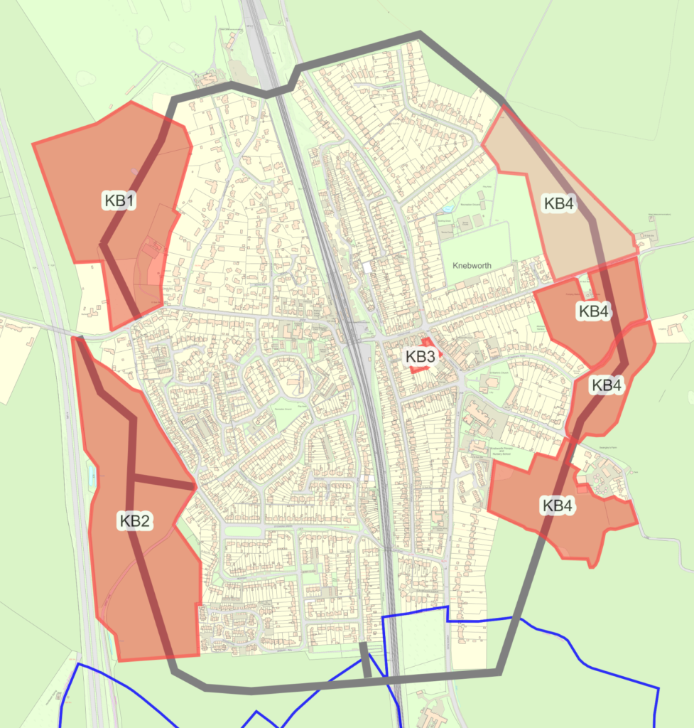
There are three large sites in the current Local Plan: two on the west side and one on east of the main village.
The way that these sites get laid out will lock in decisions about access around the village for decades to come, including placing constraints on connections for any future further growth.
To the west, KB1 & 2 with 400 homes and a new primary school is the majority of the immediate development, changing the scale of housing west of the railway line. These sites are stuck in between the A1M and the railway line, with access to the B197 limited to existing bridges and tunnels.
To the east there are plans for 200 homes on KB4 plus the potential for a future secondary school. The access for this site is problematic, as witnessed by the multiple planning applications and recent deferral decision.
Even more development to be proposed in the next Local Plan 2031+
But we’re not done yet. The District Council is developing the next Local Plan and has a process running to ask for interest in calling for more sites now.
Whilst I don’t know the specifics I would be almost sure that the two main landowners are highly likely to propose further housing plots for development around the edge of the main village.
If we are going to think long term, we must be considering these early proposals in thinking now about the road infrastructure and access choices. It’s an opportunity to use investment to start tackle long term issues.
By 2050 when Knebworth could be a small town of around 7-8,000 people with more schools. So what’s a reasonable amount of road infrastructure designed to support growth and the economy? I don’t want residents to look back thinking we knowingly made a problem worse.
So what’s the answer then?
I don’t think there is one right answer that is going to meet all policy goals across all portfolios and tiers of government. We’re going to have to find a balance between promoting walking, cycling, public transport use, supporting our retail economy growth in the village and also the reality of some car use in a growing semi-rural environment.
But the current highways developer guidance for sites actually encourages more congestion from developments to try and force a change in behaviour away from car use. This doesn’t mean the policies are wrong in isolation for a single development, however I don’t think they make sense to apply strictly en masse in a situation like Knebworth with cumulative layering of many sites all around.
I believe that local people don’t want to encourage more traffic on the B197 and through Knebworth. Given the situation with the A1M, if a major bypass was built to make the B197 a fast route north-south, I suspect it’s likely to induce more traffic in.
Also I want to discourage car use within our village, the distances are short enough that people who are able should walk or cycle wherever they can, for example to the shops or school. We need to make that safer and easier for those that can but also remember some people can’t e.g. with disabilities.
Considering travel to and from Knebworth, people here have little option other than car use when they want to go further afield, aside from the major train destinations.
There are buses but they are limited in their frequency and destinations. Cycling corridors are non-existent and footpaths are rural in nature on narrow hilly lanes without lighting. Nice for recreation but not zero-car families.
I don’t believe that it is fair to penalise Knebworth residents further by making travel by car in and out of the village intentionally much harder and compounding traffic on the B197 in the village centre, just because of the pre-existing B197 issues and lack of A1M capacity, which Knebworth didn’t cause.
The existing Masterplans and Applications for the current Local Plan sites don’t provide any strategic solutions for all the housing and proposed secondary school, or explain how the Conservation Areas will be protected. Most people that talk to me look at these proposals and can’t see how they help solve our current problems and likely make things worse.
What is the way forward?
I’d like to focus on what can be done differently to make a difference for the outcomes of people in Knebworth. I believe there is an alternative way to proceed and a middle ground between building no new road infrastructure and an M25-style bypass.
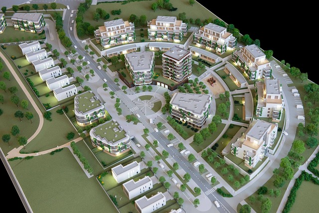
This is by allowing the sites as they are built to include some local access roads that essentially replace the existing use of inappropriate, narrow old lanes that could then be re-purposed for active travel.
These would need to be designed in a way that they are usable for residents but not fast. The roads and junctions could be designed so, in aggregate, they are not attractive to B197 through-traffic to go around Knebworth.
The above graphic is just an example of the sort of things that could be done, by replacing the use of the existing road network of rural lanes with alternative new roads through the developments, allowing local traffic around the village but designed not to induce more rat-running or through traffic.
There are already some specific ideas around the village edges.
- For KB4 we could solve the dilemma on Swangley’s Lane by joining up the bottom of KB4 development to the top of the other planned development in Woolmer Green.If we slow drivers down within Knebworth there’s little advantage of using your car for a short journey in the village. For example traffic calming measures like on Watton Road today.
- For KB1 and any future sites there, there’s the potential to link up to the B197 either via the golf club or via Old Knebworth Lane. This could then reduce the use of Deards End Lane Conservation Area.
- For KB2 there’s the potential to create an alternative route to the south to avoid use of the Stockens Green Conservation Area.
We also need the “missing” 20 mph zones in Knebworth residential streets – which Woolmer Green and Codicote already have. I am pushing my County Council colleagues for more progress on this,

County Council is in a difficult funding situation. There is little or no extra moneyavailable. But there is money available through developer contributions to the sites, which could be used both to implement more active travel and some of these relatively short and tactical road linkages.
To use this would require the willing of the two main land owners, their developers, the Highways and Planning officers to collaborate and develop viable proposals to include in Masterplans and Planning Applications.
Land owners and developers would need to compromise on some return on capital, and the officers compromise on applying policies strictly everywhere.
For the current Local Plan sites, at a minimum they should be facilitating this future, and certainly not blocking options off for the future. The next Local Plan sites may be able to implement it.
RELATED POSTS
View all


Draft masterplans for west Knebworth reflect our character but need better access and facilities
January 25, 2025 | by Paul Ward
