


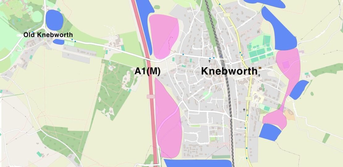
This is my response as your district and parish councillor for Knebworth into the NHDC Local Plan 2040 consultation. The consultation is available here and it ends 24th November 2026.
Executive Summary
I welcome the opportunity to respond to the North Herts Local Plan 2040 consultation. As a councillor I have been involved in aspects of policy development, I strongly support the Council’s ambition to raise standards on design codes, biodiversity net gain, climate resilience, and sustainable placemaking.
However, the emerging spatial strategy contains a fundamental structural flaw regarding Knebworth. With over 600 homes already allocated in the current Local Plan (KB1, KB2, KB4) and a further 9 promoter-led sites submitted in the Call for Sites (totalling ~80 hectares and an estimated 1,200–1,800+ homes based on similar densities), Knebworth is potentially being asked to absorb small-town scale growth, potentially doubling its population overall to 7,500–9,500 by 2040, while remaining governed by village-tier policies and only provided with village-level infrastructure.
I do not believe that this is an outcome that the local community wants or can tolerate. Knebworth also risks losing its identity through merging with Stevenage and Woolmer Green. Protecting the distinct identity and character of Knebworth is already part of the local development plan via our Knebworth Neighbourhood Plan.
To make the Local Plan sound, sustainable, and deliverable, NHDC must either reconsider its ambition to drive further growth using Knebworth and significantly limit the scale of further sites, or re-classify Knebworth. The latter would mean granting it town-level policy protections, mandate a unified strategic development framework to address the otherwise fragmented growth plans, and make any further significant growth strictly conditional on structural road and social infrastructure coming first, plus instating hard boundaries that keep Knebworth distinct.
Part A: Content and Evidence Document (Policies & Strategy)
1. Areas of Strong Support
I strongly endorse the Council’s progressive direction across the following policy areas and urge that they be retained and robustly defended at Examination:
- Design Quality & Codes (Q85–Q88): I support embedding the District Design Code into the Local Plan and developing more detailed Retail/Town Centre and Householder Design Codes to protect local character. Specifically on Masterplanning (Q87) it is essential for the multiple sites that may emerge from the Call for Sites. On Q88 the other issue that I think the Local Plan should address is strategic planning for Knebworth as a coherent community not only a collection of sites.
- Natural Environment & Biodiversity (Q40–Q46): I support requiring >10% Biodiversity Net Gain where justified and viable, retaining the 12m habitat buffer, introducing a 10m riparian buffer for chalk streams and rivers, and embedding Urban Greening Factors (0.3/0.4) and Urban Tree Canopy Cover standards into policy. Our chalk streams in particular are a rare and distinctive feature of our district that we should be seeking to protect as much as possible.
- Climate Change, Energy & Water (Q50–Q59): I support policies encouraging battery storage, community energy schemes, heat networks, retrofit-first circular economy principles, and the 85 litres/person/day water efficiency target given North Herts’ status as an area of serious water stress. I particularly support Q55 to promote renovation over demolition. I have seen several cases locally where such proposals threaten our Conservation Areas and more should be done in policy to make better use of existing buildings.
- Transport Accountability and Cycle Requirements (Q65–Q67): I strongly support the proposed Monitor and Manage Fund (developer bonds) to ensure Travel Plan targets are genuinely met rather than treated as box-ticking exercises. On questions Q66–Q67 regarding cycling and shared mobility provision in developments, Knebworth is relatively hilly and if we want to encourage more people to cycle (e.g. to/from Stevenage up a 30m+ elevation hill) then provision for e-bikes is key to help less athletic people use bikes to access other local communities easily, both private ones for those who can afford it and shared schemes for wider public use.
2. Settlement Hierarchy & Knebworth’s Re-classification (Q4, Q5, Q6, Q7)
- The Issue: The consultation proposes categorising settlements using current baselines for population, services, and transport connectivity. Retaining Knebworth as a generic “Category A / Larger Village” (subject to a 30 dph baseline) ignores the reality of its committed and proposed growth, as outlined above.
- Requested Change (Q4, Q5, Q7): The settlement hierarchy methodology must explicitly account for projected 2040 population scale and cumulative allocations, not just historical baselines. Knebworth must be re-classified as a “Small Town” or “Key Service Centre.” It may need to sit in its own category “above” the other villages and “below” larger towns. But this needs recognising and the framework adapting to match the reality.
- The Precedent: Neighbouring East Hertfordshire District Council designates Buntingford (baseline population ~5,500–6,000) as a principal town with its own dedicated policy chapter (BUNT1–3), a protected Minor Town Centre boundary, strategic employment land, and coordinated school expansion safeguards. Knebworth, with a mainline railway station and a projected population approaching 8,000–9,600+, requires similar equivalent policy status.
3. Town Centres, High Street Protection & Health Hubs (Q32, Q35, Q36, Q38, Q39)
- The Issue: Knebworth is currently listed as one of 13 subordinate “Local Centres,” grouped alongside minor suburban parades like Ninesprings in Hitchin. This leaves the London Road commercial corridor without formal town centre boundary protections, exposing vital retail frontages to piecemeal Permitted Development residential conversions (e.g. Chas Lowe vacant frontage for years now from McCarthy & Stone residential home, formerly KB3).
- Requested Change (Q32 & Q39): The updated Retail Needs Study must upgrade Knebworth to a formal “Minor Town Centre” with a defined boundary along London Road, supported by Article 4 Directions where necessary to safeguard commercial vitality.
- High Street Traffic (Q35 & Q36): I strongly support improving the public realm and removing through-traffic from centres. However, in Knebworth, the High Street is the B197. Without a relief route to divert through-traffic and A1(M) overspill, public realm improvements alone cannot resolve High Street congestion and air quality issues. This conflict needs resolving both in the Local Plan and with the county council on the Local Transport Plan 5 finalisation. Knebworth centre cannot be both part of a strategic corridor for A1(M) overspill and a small town centre. This would not be acceptable in the North Herts towns. I appreciate that the county council is looking at tactical solutions in the shopping area but both authorities need to work together on a more strategic solution to this problem.
- Healthcare (Q38): I support policies promoting Neighbourhood Health Hubs, but note that the document only references Baldock, Hitchin, and Letchworth. Given Knebworth’s projected growth, NHDC must work with the Central East ICB to include Knebworth in Neighbourhood Health Hub planning.
4. Masterplanning & Upholding the Neighbourhood Plan (Q6, Q87, Q88)
- The Issue: The consultation asks whether the 100-dwelling threshold for masterplans remains appropriate (Q87). Where a settlement faces multiple adjacent, promoter-led sites, fragmented 100-unit masterplans fail to address cumulative infrastructure deficits. They are necessary but not sufficient, and Knebworth also requires community level strategic planning.
- Requested Change (Q87): Retain the 100-dwelling threshold for standalone sites, but introduce a cumulative settlement trigger: where a settlement is allocated multiple sites totalling 250+ dwellings, the Local Plan must mandate a single, unified Strategic Development Framework (SDF) / small town-wide masterplan.
- Neighbourhood Plan Alignment (Q6 & Q88): The made Knebworth Neighbourhood Plan (currently undergoing its 1st Review) is a statutory part of the Development Plan. The Local Plan’s spatial strategy must explicitly respect its core vision of maintaining Knebworth’s Garden Village character and distinctive identity, rather than overriding it with piecemeal urban-scale allocations.
5. Spatial Strategy, Growth Options & Preventing Coalescence (Q5, Q6, Q7, Q9, Q10, Q44)
- The Structural Contradiction in Growth Options 1–3 (Q6, pp. 40–47): The Council proposes combining Options 1–3 (Infill, Urban Expansion, and Dispersed Village Growth). In Table 6 (p. 45), Option 3 is explicitly defined as “small-scale housing growth” intended to meet local needs and “avoid putting too much pressure onto one single settlement.” Allocating 600+ homes already committed in Knebworth alongside up to 1,200–1,800+ promoter-led Call for Sites homes is the antithesis of dispersed village growth. It treats Knebworth as an Option 2 (Urban Expansion) location by volume, while denying it Option 2’s comprehensive masterplanning, strategic employment provision, and upfront infrastructure delivery.
- Flaws in the Settlement Hierarchy & Density Framework (Q5 & Q9, pp. 38–40 & 48): The proposed hierarchy criteria rely heavily on service checklists and rail proximity—where Knebworth scores highly due to its mainline station—without weighting hard infrastructure ceilings (specifically the B197/Watton Road railway bridge bottleneck, lack of step-free station access, school/GP capacity, and Thames Water Rye Meads constraints). Furthermore, p. 48 highlights that national policies (NDMPs) require minimum densities of 35–45 dph within 800m of well-connected railway stations. Imposing urban-tier densities onto a settlement managed under a 30 dph “Larger Village” framework will intensify congestion and overwhelm local services.
- Green Belt Reliance & Acute Coalescence Risk (Q10, pp. 50–52): The Council proposes relying solely on national NPPF Green Belt policies (Q10), while the “Rural Area beyond the Green Belt” designation does not cover Knebworth. Table 5 (p. 43) explicitly warns that edge-of-settlement expansion “can make neighbouring towns appear to expand towards one another, reducing the distinction between settlements and weakening their individual identity.” As Figure 5 (p. 43) illustrates, Knebworth sits in a narrow corridor immediately south of Stevenage and north of Woolmer Green/Welwyn. Without explicit local spatial protections, promoter-led growth risks turning the B197 corridor into a continuous urban strip.
- Requested Changes:
- Curb Further Allocations (Q5, Q6 & Q7): Revise the settlement hierarchy criteria (Q5) to incorporate cumulative committed growth and infrastructure capacity ceilings as limiting factors. Under Option 3 (Q6), cap Knebworth to genuine, small-scale local need—recognising that 600+ allocated homes have yet to be built—and address wider long-term housing pressures through coordinated strategic options (including Option 4 / Hertfordshire’s Spatial Development Strategy, Q7) rather than overloading constrained villages.
- Bespoke Strategic Framework (Q6 & Q9): If the next Local Plan ends up using Knebworth to absorb urban-scale growth, it must formally remove Knebworth from Option 3, re-classify it above village tier, and bring forward a single, infrastructure-first Strategic Development Framework that reconciles station-area density requirements (Q9) with local character and transport capacity.
- Hard Anti-Coalescence Boundaries (Q10 & Q44): Regardless of growth scale, the Local Plan must include a dedicated local spatial policy safeguarding the strategic green gaps between Knebworth, Stevenage, and Woolmer Green. On Q10 I believe a stronger anti-coalescence mechanism needs to be sought; re-classifying Knebworth may help this. In response to Q44, I strongly support designating Locally Valued Landscapes and request that the open countryside buffering the B197 corridor and Knebworth’s historic edges be formally assessed for inclusion.
6. Transport, Connectivity & Structural Road Infrastructure (Q61–Q64, Q74–Q76)
- Connectivity Definitions (Q61–Q63): I agree that bus services below the “low-quality” threshold should not count (Q63). However, for Q61 & Q62, proximity to a railway station (within 800m) must not automatically classify a site as “sustainably connected” or “well-connected” unless the station has step-free access and safe, continuous pedestrian/cycle routes—neither of which are currently met at Knebworth. Examples include the lack of step-free access at Knebworth station, for which government have not prioritised funding, plus the dangerous pedestrian access to the train station from the village centre via the narrow pavement and road under the adjacent bridge.
- Cumulative Traffic & Relief Infrastructure (Q64): Consistent with my recent representation to Hertfordshire County Council on Draft LTP5, transport assessments must model the cumulative impact of all committed and proposed growth along the B197 and A1(M) corridor (including Stevenage and Welwyn Hatfield cross-boundary traffic), rather than assessing sites in isolation.
- Safeguarding Land for Infrastructure: The Local Plan must explicitly safeguard land for a network of structural relief roads to take through-traffic off the London Road High Street and bypass the Watton Road railway bridge bottleneck, alongside safeguarding land for Travel Hubs (Q74–Q76).
Part B: Response to the Call for Sites (Knebworth)
1. Context: Existing Commitments vs. New Submissions
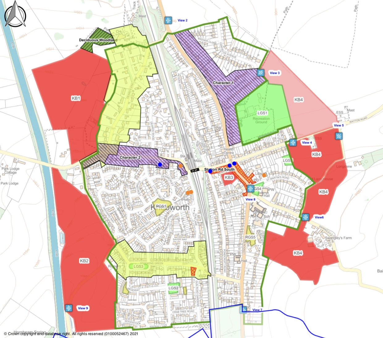
Before any new sites are considered in the HELAA, NHDC must account for the fact that Knebworth already has over 600 homes allocated across KB1 (Deards End), KB2 (Gipsy Lane), and KB4 (East of Knebworth), none of which have yet commenced construction. Adding all the 9 newly submitted sites (~80 hectares) would represent an unsustainable ~75% expansion of the local community without any proven infrastructure delivery. The only one major new piece of infrastructure in the existing Local Plan to 2031 is a new primary school on KB2 and even this I believe is under debate with the education authority now.
Crucially, none of the 9 submitted sites sit on land identified as Grey Belt in the Council’s own 2026 Green Belt Study (the only Grey Belt parcel at Knebworth, KN3, has no submission). All 9 submissions sit on functioning Green Belt land that performs vital roles in checking sprawl and preventing coalescence.
2. Strategic Tests & Objections to Submitted Sites
I do not oppose all proportionate, well-planned growth in Knebworth, provided it is led by infrastructure. However, in assessing the 9 submitted sites for the HELAA and Draft Local Plan, I request that the council apply the following red lines and discount sites that fail them:
Zero Tolerance for Coalescence (Northern & Southern Gaps)
- South-West / Woolmer Green Gap (e.g., Site 49200 – 32 ha, Green Belt parcel KN5): I strongly oppose allocations that erode the fragile separation between Knebworth, Woolmer Green, and Oaklands. The Council’s own Green Belt assessment warns that merging these settlements would create a continuous town-sized urban area. The proposed sites should be assessed and scaled or rejected accordingly to provide this protection.
- Northern / Stevenage Gap: Any site eroding the strategic gap between Knebworth and Stevenage along the A1(M)/B197 corridor must be curtailed and/or designed to prevent those sites or future in-fill meaning Knebworth becomes a southern suburb of Stevenage.
- Old Knebworth: I oppose piecemeal encroachments on Park Lane that undermine the distinct, historic identity of the separate hamlet of Old Knebworth. Even a site of 1.93 ha (potentially ~43–46 homes at the proposed 30 dph village minimum) would be disproportionately large for a small historic hamlet and should not be allocated simply to help fill the NPPF 1–2.5 ha site-size bracket.
Roads Before Homes (B197 & Watton Road Bridge)
- Knebworth’s highway network—centred on a single crossroads, the High Street, and the Watton Road railway bridge bottleneck—is already at capacity and regularly paralysed by A1(M) overspill.
- Sites that simply feed additional vehicular traffic onto the existing village road network without funding and delivering a structural relief route must be assessed as unachievable and unsustainable. It is not credible to expect that modal shift alone will absorb all additional load.
Protection of Neighbourhood Plan Buffers & Countryside
- Sites that extend existing allocations (such as KB4) further into open countryside and strip away green buffers protected under the Knebworth Neighbourhood Plan (e.g., Policy KBBE8) should be discounted.
Binding Social Infrastructure Delivery
- No further large-scale site allocations in Knebworth should be brought forward unless bound into a Strategic Development Framework that legally guarantees the timely expansion of primary and secondary school places, GP/healthcare capacity, and foul/surface water drainage (noting Thames Water’s Rye Meads catchment constraints) prior to occupation.
RELATED POSTS
View all


Draft masterplans for west Knebworth reflect our character but need better access and facilities
January 25, 2025 | by Paul Ward
September update: development discussions, recycling issues, flags
September 17, 2025 | by Paul Ward
August update: KB4 deferment, recycling, hedges
August 17, 2025 | by Paul Ward